
Arizona Metals Corp. (TSX.V:AMC, OTCQX:AZMCF) (the “Company” or “Arizona Metals”) is pleased to announce the results of an additional four drill holes at the recently discovered gold-rich zone of open-ended mineralization at the Kay Mine, in an area previously untested by historic drilling or exploration.
This press release features multimedia. View the full release here: https://www.businesswire.com/news/home/20210726005247/en/

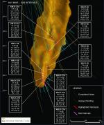
Figure 1. Section view looking north. See Tables 1 and 2 for additional details. The true width of mineralization is estimated to be 50% to 97% of reported core width, with an average of 80%.(Graphic: Business Wire)
Branch Hole 27B intersected 97 m at a grade of 1.3% Cu, 1.6 g/t Au, 3.2% Zn, and 32 g/t Ag, including higher-grade intervals of 15 m grading 5.0% Cu, 0.4 g/t Au, 0.4% Zn, and 19 g/t Ag, as well as 21 m grading 4.6 g/t Au, 9.0% Zn, 0.9% Cu, and 82 g/t Ag. This hole is the deepest drilled to date by Arizona Metals Corp, and extends the new gold-zinc discovery zone by 20%, to a depth of 750 metres.
Branch Hole 27A intersected 103 m at a grade of 0.8% Cu, 1.1 g/t Au, 1.9% Zn, and 36 g/t Ag, including higher grade intervals of 21 m grading 3.2% Cu, 1.4 g/t Au, 1.3% Zn, and 19 g/t Ag, as well as 18 m grading 0.7% Cu, 2.7 g/t Au, 4.7% Zn, and 92 g/t Ag.
Hole 28, which was drilled to test for vertical continuity of high-grade zones between holes 25 and 24, intersected 54 m at a grade of 1.9% Cu, 2.9 g/t Au, 5.0% Zn, and 29 g/t Ag, from a vertical depth of 585 m below surface. Hole 28 includes three separate higher-grade intervals of 11.4 m grading 4.3 g/t Au, 9.3% Zn, 0.5% Cu and 32 g/t Ag, as well as 7.9 m grading 4.4% Cu, 9.5 g/t Au, 10.3% Zn, and 93 g/t Ag, and also 2.2 m grading 16.1% Cu, 0.8 g/t Au, and 56 g/t Ag.
Hole 27 was drilled as a trunk hole at the northern edge of the new discovery zone, and intersected 31.4 m grading 1.6% Cu, 0.2 g/t Au, 0.7% Zn and 9.0 g/t Ag, and 26 m further downhole, intersected 13 m grading 2.9% Cu, 0.5 g/t Au, 0.2% Zn, and 8.4 g/t Ag.
These newly defined, wide, high-grade intervals demonstrate the potential to add a significant tonnage of gold-zinc mineralization outside of the historic resource.
Marc Pais, CEO, commented “The four drill holes released today validate and extend the new gold-rich zinc zone discovery, with broad intervals of mineralization in the discovery zone ranging from 54 m to 103 m, and true widths estimated at an average of 80%. Hole 27 demonstrates that mineralization extends at least 100 m deeper than reported by previous operators. Holes 27A and 27B have encountered excellent grades and thicknesses, as good or better than those reported in the discovery holes, while also demonstrating the potential for the discovery zone to both extend at depth and increase on strike as it deepens. The first few holes drilled in the discovery zone were on a large step-out spacing of 100 m to 150 m. Subsequent branch holes to infill between these holes are demonstrating excellent vertical continuity, as well as lateral extension of mineralization on strike to both the north and south. Of particular note is hole 28 (located at the vertical mid-point of holes 24 and 25), which intersected 54m of mineralization, including significant intervals of higher grade within. This hole is the widest zone of high-grade drilled at the project to date, and demonstrates excellent continuity of both grade and thickness with the holes above and below. Today’s results have increased the vertical extent of the discovery zone (now defined from hole 21A to 27) to approximately 400 m. Drill holes are currently underway to test for further extensions by testing 200 m above hole 21A and also 200 m below hole 27. With the recently completed financing of $21 million, the Company is fully-funded to complete the 75,000 metre Phase 2 expansion program.”
Covid-19 Monitoring and Mitigation Procedures
The Company’s drill contractor, Boart Longyear, has instituted Covid-19 monitoring procedures for all drill crew members, including daily temperature and symptom checks. Arizona Metals Corp will be provided with daily health tracking updates for the drill crews and has also instituted its own social distancing policies and provided a guidance manual for employees at site.
Table 1. Results of Phase 2 Drill Program at Kay Mine, Yavapai County, Arizona. The true width of mineralization is estimated to be 50% to 97% of reported core width, with an average of 80%.
| Arizona Metals Kay Mine Drill Intercepts | Analyzed Grade | ||||||||
| Hole ID | From m | To m | Length m | Cu % | Au g/t | Zn % | Ag g/t | Pb % | Vertical Depth Below Surface m |
| KM-21-17 | 429.5 | 449.9 | 20.4 | 1.81 | 1.10 | 1.20 | 21.2 | 0.17 | 300 |
| including | 429.5 | 434.0 | 4.6 | 4.61 | 1.73 | 1.91 | 29.1 | 0.24 | |
| including | 432.7 | 434.0 | 1.4 | 0.52 | 6.81 | 8.29 | 40.0 | 1.10 | |
| KM-21-17 | 504.4 | 505.4 | 0.9 | 1.19 | 4.73 | 0.05 | 9.0 | 0.00 | 356 |
| KM-21-18 | 404.3 | 429.8 | 25.5 | 0.35 | 0.86 | 1.71 | 15.8 | 0.23 | 255 |
| including | 408.6 | 410.6 | 2.0 | 0.50 | 2.22 | 7.25 | 64.4 | 0.82 | |
| including | 424.9 | 427.3 | 2.4 | 1.60 | 2.59 | 3.16 | 18.0 | 0.52 | |
| KM-21-18A | 391.4 | 423.8 | 32.5 | 1.09 | 0.62 | 1.25 | 17.6 | 0.15 | 233 |
| including | 393.3 | 395.8 | 2.4 | 9.57 | 2.83 | 2.72 | 40.9 | 0.28 | |
| KM-21-19 | 377.8 | 378.3 | 0.5 | 3.39 | 5.59 | 6.83 | 128.0 | 0.63 | 337 |
| KM-21-20 | 442.7 | 443.6 | 0.9 | 2.56 | 0.52 | 3.52 | 18.5 | 0.14 | 362 |
| KM-21-20 | 456.0 | 458.1 | 2.1 | 1.49 | 0.35 | 0.14 | 6.0 | 0.04 | 370 |
| KM-21-21 | 452.6 | 495.5 | 42.8 | 0.80 | 0.78 | 1.52 | 15.1 | 0.15 | 362 |
| including | 488.7 | 493.5 | 4.8 | 0.26 | 2.50 | 6.13 | 27.6 | 0.54 | |
| KM-21-21A | 422.0 | 431.4 | 9.4 | 1.17 | 0.57 | 2.25 | 8.6 | 0.36 | 362 |
| KM-21-21A | 439.1 | 502.1 | 63.0 | 0.45 | 1.28 | 3.14 | 58.8 | 0.77 | 366 |
| including | 465.0 | 481.9 | 16.9 | 0.52 | 2.45 | 4.05 | 80.9 | 0.99 | |
| KM-21-23 | 394.4 | 401.4 | 7.0 | 0.36 | 0.93 | 1.94 | 13.5 | 1.17 | 313 |
| KM-21-23 | 438.6 | 459.2 | 20.6 | 0.17 | 1.18 | 1.93 | 27.8 | 0.37 | 336 |
| KM-21-24 | 501.2 | 592.1 | 90.8 | 0.45 | 1.33 | 3.42 | 44.3 | 0.41 | 470 |
| including | 501.2 | 521.7 | 20.4 | 1.34 | 1.70 | 6.35 | 113.1 | 0.66 | |
| including | 520.9 | 521.7 | 0.8 | 1.75 | 16.50 | 9.55 | 574.0 | 1.22 | |
| including | 575.9 | 592.1 | 16.2 | 0.16 | 2.50 | 6.00 | 44.4 | 0.79 | |
| including | 588.7 | 590.4 | 1.7 | 0.47 | 9.98 | 23.70 | 18.2 | 0.13 | |
| KM-21-25 | 662.6 | 741.3 | 78.6 | 1.41 | 2.33 | 2.79 | 43.4 | 0.35 | 638 |
| including | 663.2 | 672.7 | 9.4 | 8.06 | 1.84 | 1.31 | 92.3 | 0.15 | |
| including | 693.0 | 703.9 | 11.0 | 0.68 | 6.28 | 10.40 | 99.7 | 1.17 | |
| KM-21-25A | 654.7 | 719.9 | 65.2 | 1.04 | 1.94 | 2.15 | 18.8 | 0.18 | 624 |
| including | 655.5 | 662.8 | 7.3 | 3.66 | 2.09 | 1.85 | 30.2 | 0.21 | |
| including | 710.8 | 716.9 | 6.1 | 2.72 | 7.95 | 3.73 | 37.4 | 0.31 | |
| KM-21-25B | 647.2 | 648.9 | 1.7 | 0.13 | 0.58 | 2.41 | 62.1 | 0.64 | 610 |
| KM-21-25B | 655.6 | 659.9 | 4.3 | 0.93 | 0.91 | 0.91 | 25.3 | 0.19 | 615 |
| KM-21-25B | 666.0 | 667.8 | 1.8 | 0.60 | 0.72 | 2.98 | 33.5 | 0.43 | 620 |
| KM-21-25B | 673.3 | 674.7 | 1.4 | 0.08 | 2.10 | 2.39 | 23.0 | 0.33 | 628 |
| KM-21-25B | 681.2 | 682.6 | 1.4 | 0.09 | 1.54 | 2.98 | 11.0 | 0.35 | 631 |
| KM-21-26 | 506.7 | 582.8 | 76.0 | 0.79 | 1.61 | 4.23 | 32.6 | 0.54 | 480 |
| including | 511.1 | 526.1 | 14.9 | 0.73 | 1.78 | 9.68 | 43.3 | 0.77 | |
| including | 573.8 | 582.8 | 9.0 | 4.02 | 6.06 | 3.32 | 18.2 | 0.19 | |
| KM-21-27 | 706.8 | 738.2 | 31.4 | 1.58 | 0.16 | 0.69 | 9.0 | 0.06 | 670 |
| KM-21-27 | 764.4 | 777.4 | 13.0 | 2.85 | 0.48 | 0.17 | 8.4 | 0.02 | 688 |
| KM-21-27A | 666.3 | 769.4 | 103.1 | 0.79 | 1.06 | 1.90 | 35.8 | 0.42 | 678 |
| including | 666.3 | 687.0 | 20.7 | 3.21 | 1.39 | 1.26 | 19.4 | 0.20 | |
| including | 706.4 | 724.6 | 18.3 | 0.69 | 2.69 | 4.70 | 92.2 | 1.21 | |
| including | 752.9 | 763.8 | 11.0 | 0.07 | 1.07 | 4.68 | 95.3 | 0.98 | |
| KM-21-27B | 665.8 | 762.9 | 97.1 | 1.31 | 1.62 | 3.21 | 31.7 | 0.40 | 660 |
| including | 702.0 | 723.0 | 21.0 | 0.87 | 4.56 | 9.03 | 81.5 | 1.10 | |
| including | 723.0 | 738.2 | 15.2 | 4.97 | 0.36 | 0.42 | 18.7 | 0.05 | |
| KM-21-28 | 640.7 | 694.9 | 54.3 | 1.87 | 2.85 | 5.03 | 29.4 | 0.70 | 584 |
| including | 660.2 | 671.6 | 11.4 | 0.54 | 4.29 | 9.30 | 32.2 | 1.17 | |
| including | 681.1 | 689.0 | 7.9 | 4.39 | 9.47 | 10.34 | 93.1 | 2.41 | |
| including | 690.4 | 692.6 | 2.2 | 16.06 | 0.82 | 0.06 | 55.8 | 0.01 | |
Table 2. Results of Phase 1 Drill Program at Kay Mine, Yavapai County, Arizona. The true width of mineralization is estimated to be 50% to 97% of reported core width, with an average of 80%.
| Arizona Metals Kay Mine Drill Intercepts | Analyzed Grade | ||||||||
| Hole ID | From m | To m | Length m | Cu % | Au g/t | Zn % | Ag g/t | Pb % | Vertical Depth Below Surface m |
| KM-20-01 | 275.8 | 281.5 | 5.6 | 0.57 | 0.48 | 1.20 | 11.6 | 0.18 | 156 |
| including | 275.8 | 276.5 | 0.6 | 0.50 | 1.22 | 5.04 | 32.0 | 0.73 | |
| including | 279.8 | 281.5 | 1.6 | 1.21 | 0.98 | 1.49 | 22.6 | 0.23 | |
| KM-20-02 | 297.8 | 300.8 | 3.0 | 0.77 | 0.20 | 0.04 | 1.4 | 0.01 | 172 |
| KM-20-03 | 256.3 | 259.1 | 2.7 | 3.40 | 1.01 | 0.65 | 69.6 | 0.09 | 120 |
| including | 256.3 | 257.3 | 0.9 | 7.42 | 1.79 | 1.11 | 56.0 | 0.17 | |
| KM-20-03 | 292.2 | 292.6 | 0.5 | 2.43 | 0.19 | 0.15 | 2.0 | 0.04 | 152 |
| KM-20-03 | 295.4 | 295.8 | 0.5 | 1.35 | 0.80 | 0.91 | 6.0 | 0.06 | 154 |
| KM-20-03A | 252.4 | 256.9 | 4.6 | 3.70 | 2.55 | 0.27 | 35.6 | 0.03 | 122 |
| including | 252.4 | 253.1 | 0.8 | 9.74 | 6.34 | 0.40 | 164.0 | 0.11 | |
| KM-20-05 | 266.6 | 269.0 | 2.4 | 6.47 | 1.94 | 0.57 | 43.3 | 0.14 | 150 |
| including | 266.6 | 267.8 | 1.2 | 10.60 | 2.21 | 1.05 | 50.0 | 0.26 | |
| KM-20-06 | 267.9 | 281.5 | 13.5 | 1.02 | 0.85 | 1.23 | 45.6 | 0.30 | 158 |
| including | 267.9 | 268.4 | 0.5 | 1.54 | 2.20 | 6.10 | 31.0 | 0.81 | |
| including | 276.6 | 281.5 | 4.9 | 1.86 | 0.87 | 1.96 | 92.1 | 0.42 | |
| including | 280.0 | 281.0 | 1.1 | 3.22 | 1.03 | 0.64 | 340.0 | 0.04 | |
| KM-20-09 | 588.1 | 588.4 | 0.3 | 0.91 | 1.74 | 1.86 | 15.0 | 0.40 | |
| KM-20-09 | 613.4 | 614.1 | 0.7 | 0.90 | 1.81 | 1.04 | 10.0 | 0.08 | |
| KM-20-09 | 614.6 | 614.9 | 0.3 | 2.64 | 0.36 | 0.98 | 19.0 | 0.10 | |
| KM-20-09 | 632.8 | 638.9 | 6.1 | 0.12 | 4.18 | 8.02 | 41.7 | 0.82 | 575 |
| including | 633.6 | 637.9 | 4.4 | 0.15 | 5.46 | 9.06 | 33.1 | 0.50 | |
| including | 636.9 | 637.9 | 1.1 | 0.17 | 9.77 | 14.65 | 68.0 | 0.78 | |
| KM-20-10 | 563.6 | 568.5 | 4.9 | 2.39 | 2.16 | 3.27 | 24.9 | 0.31 | 490 |
| including | 563.6 | 566.6 | 3.0 | 3.66 | 2.42 | 3.16 | 28.2 | 0.32 | |
| including | 567.2 | 568.5 | 1.2 | 0.33 | 2.52 | 5.10 | 28.4 | 0.43 | |
| KM-20-10 | 574.2 | 574.9 | 0.6 | 0.12 | 4.33 | 11.30 | 113.0 | 0.16 | 498 |
| KM-20-10 | 577.7 | 579.3 | 1.6 | 0.03 | 0.70 | 4.38 | 45.9 | 0.68 | 500 |
| KM-20-10 | 582.3 | 583.1 | 0.8 | 0.03 | 0.42 | 2.90 | 51.0 | 1.07 | 502 |
| KM-20-10A | 521.2 | 522.5 | 1.3 | 2.13 | 1.27 | 7.46 | 51.1 | 0.91 | 437 |
| KM-20-10A | 527.9 | 538.6 | 10.7 | 1.32 | 1.66 | 2.58 | 27.2 | 0.30 | 442 |
| including | 527.9 | 529.4 | 1.5 | 6.69 | 0.92 | 1.62 | 30.2 | 0.07 | |
| including | 532.2 | 535.3 | 3.1 | 0.72 | 1.75 | 2.99 | 34.3 | 0.42 | |
| including | 537.2 | 538.6 | 1.4 | 0.16 | 7.29 | 9.06 | 79.2 | 0.60 | |
| KM-20-10B | 503.0 | 530.7 | 27.6 | 0.87 | 0.97 | 1.76 | 21.3 | 0.32 | 423 |
| including | 503.0 | 509.6 | 6.6 | 1.78 | 1.55 | 2.55 | 29.8 | 0.37 | |
| including | 513.9 | 518.3 | 4.4 | 1.08 | 1.89 | 4.05 | 47.4 | 0.68 | |
| including | 527.2 | 530.7 | 3.5 | 1.91 | 2.32 | 3.93 | 52.9 | 0.99 | |
| KM-20-10C | 523.9 | 530.7 | 6.8 | 0.58 | 3.32 | 5.84 | 102.0 | 1.15 | 422 |
| including | 523.9 | 528.2 | 4.3 | 0.88 | 4.89 | 7.61 | 125.2 | 1.45 | |
| including | 525.6 | 526.4 | 0.8 | 0.52 | 16.65 | 21.40 | 214.0 | 2.76 | |
| KM-20-11 | 554.1 | 556.9 | 2.7 | 4.14 | 2.83 | 3.56 | 70.0 | 0.28 | 490 |
| KM-20-12 | 371.9 | 376.7 | 4.9 | 3.99 | 0.37 | 0.62 | 12.4 | 0.07 | 318 |
| including | 371.9 | 373.7 | 1.9 | 8.49 | 0.67 | 1.53 | 28.0 | 0.16 | |
| KM-20-12 | 379.5 | 405.4 | 25.9 | 0.73 | 0.08 | 0.08 | 2.3 | 0.01 | 326 |
| KM-20-13 | 443.6 | 486.8 | 43.1 | 1.68 | 1.26 | 1.67 | 23.3 | 0.24 | 341 |
| including | 444.4 | 459.6 | 15.2 | 3.42 | 1.80 | 2.36 | 38.5 | 0.39 | |
| including | 444.4 | 447.1 | 2.7 | 1.02 | 3.74 | 10.64 | 55.0 | 1.88 | |
| including | 451.4 | 455.8 | 4.4 | 8.41 | 1.18 | 0.16 | 65.3 | 0.02 | |
| KM-20-14 | 421.7 | 461.6 | 39.9 | 1.47 | 1.00 | 1.67 | 18.4 | 0.19 | 314 |
| including | 426.3 | 429.8 | 3.5 | 9.56 | 1.28 | 0.95 | 30.0 | 0.07 | |
| including | 457.2 | 460.7 | 3.5 | 0.36 | 2.58 | 8.33 | 26.3 | 0.38 | |
| KM-20-14A | 404.6 | 409.0 | 4.4 | 1.67 | 1.48 | 2.50 | 79.2 | 0.41 | 303 |
| including | 404.6 | 406.4 | 1.7 | 4.08 | 2.46 | 5.02 | 173.6 | 0.53 | |
| KM-20-14A | 421.0 | 443.5 | 22.5 | 0.86 | 0.72 | 1.51 | 15.9 | 0.18 | 312 |
| including | 421.0 | 421.8 | 0.8 | 9.81 | 2.91 | 1.69 | 45.0 | 0.19 | |
| including | 421.0 | 425.0 | 4.1 | 3.23 | 1.14 | 1.30 | 21.4 | 0.14 | |
| KM-20-15 | 506.8 | 510.1 | 3.3 | 0.05 | 0.33 | 3.73 | 192.0 | 1.75 | 402 |
| KM-20-16 | 480.4 | 518.8 | 38.4 | 0.85 | 0.81 | 2.24 | 24.3 | 0.25 | 385 |
| including | 480.4 | 492.9 | 12.5 | 1.63 | 1.98 | 4.23 | 48.5 | 0.50 | |
| including | 480.4 | 483.4 | 3.0 | 2.40 | 4.74 | 7.49 | 77.9 | 0.91 | |
| including | 489.8 | 492.9 | 3.0 | 3.61 | 2.59 | 6.90 | 100.7 | 0.92 | |
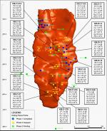
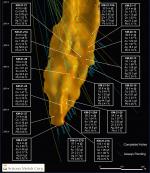
Table 3. Locations of Phase 1 and 2 Program drill holes completed and in progress at Kay Mine, Arizona
| Hole ID | Phase | Drill Pad | Zone | Collar East WGS84 | Collar North WGS84 | Collar Elev m | Collar Az | Collar Dip | Total Depth m |
| KM-20-01 | 1 | Pad 1 | North | 392684 | 3769388 | 643 | 78 | -48 | 335 |
| KM-20-02 | 1 | Pad 1 | North | 392684 | 3769388 | 643 | 75 | -50 | 304 |
| KM-20-03 | 1 | Pad 1 | North | 392684 | 3769388 | 643 | 72 | -43.3 | 366 |
| KM-20-03A | 1 | Pad 1 | North | 392684 | 3769388 | 643 | 72 | -43.3 | 321 |
| KM-20-04 | 1 | Pad 1 | North | 392684 | 3769388 | 643 | 65.1 | -47.5 | 354 |
| KM-20-05 | 1 | Pad 1 | North | 392684 | 3769388 | 643 | 73.3 | -47.2 | 349 |
| KM-20-06 | 1 | Pad 1 | North | 392684 | 3769388 | 643 | 81.3 | -48.3 | 317 |
| KM-20-07 | 1 | Pad 1 | North | 392684 | 3769388 | 643 | 85.6 | -47.6 | 308 |
| KM-20-08 | 1 | Pad 2 | South | 392638 | 3769266 | 653 | 91.1 | -77.1 | 36 |
| KM-20-09 | 1 | Pad 2 | South | 392638 | 3769266 | 653 | 92.1 | -77 | 671 |
| KM-20-10 | 1 | Pad 2 | South | 392638 | 3769266 | 653 | 96.3 | -72.2 | 645 |
| KM-20-10A | 1 | Pad 2 | South | 392638 | 3769266 | 653 | 96.3 | -72.2 | 600 |
| KM-20-10B | 1 | Pad 2 | South | 392638 | 3769266 | 653 | 96.3 | -72.2 | 555 |
| KM-20-10C | 1 | Pad 2 | South | 392638 | 3769266 | 653 | 96.3 | -72.2 | 560 |
| KM-20-11 | 1 | Pad 3 | North | 392552 | 3769328 | 638 | 57.3 | -67.5 | 653 |
| KM-20-12 | 1 | Pad 1 | North | 392684 | 3769388 | 643 | 95.7 | -70.8 | 583 |
| KM-20-13 | 1 | Pad 1 | South | 392684 | 3769388 | 643 | 124 | -66.5 | 524 |
| KM-20-14 | 1 | Pad 1 | South | 392684 | 3769388 | 643 | 133.6 | -66 | 550 |
| KM-20-14A | 1 | Pad 1 | South | 392684 | 3769388 | 643 | 133.6 | -66 | 549 |
| KM-20-15 | 1 | Pad 2 | South | 392638 | 3769266 | 653 | 106.7 | -66.8 | 572 |
| KM-20-16 | 1 | Pad 2 | South | 392638 | 3769266 | 653 | 91.5 | -68.9 | 581 |
| KM-21-17 | 2 | Pad 2 | South | 392638 | 3769266 | 653 | 90.5 | -59.5 | 892 |
| KM-21-18 | 2 | Pad 2 | South | 392638 | 3769266 | 653 | 89.8 | -55 | 518 |
| KM-21-18A | 2 | Pad 2 | South | 392638 | 3769266 | 653 | 89.8 | -55 | 472 |
| KM-21-19 | 2 | Pad 1 | North | 392684 | 3769388 | 643 | 59.3 | -69.5 | 482 |
| KM-21-20 | 2 | Pad 2 | North | 392638 | 3769266 | 653 | 53.7 | -67.3 | 553 |
| KM-21-21 | 2 | Pad 1 | South | 392684 | 3769388 | 643 | 126 | -70 | 561 |
| KM-21-21A | 2 | Pad 1 | South | 392684 | 3769388 | 643 | 126 | -70 | 556 |
| KM-21-22 | 2 | Pad 3 | Grav | 392552 | 3769328 | 638 | 33 | -63 | 725 |
| KM-21-22A | 2 | Pad 3 | Grav | 392552 | 3769328 | 638 | 33 | -63 | 694 |
| KM-21-23 | 2 | Pad 1 | South | 392684 | 3769388 | 643 | 114.2 | -66.3 | 528 |
| KM-21-24 | 2 | Pad 1 | South | 392684 | 3769388 | 643 | 119 | -75.1 | 623 |
| KM-21-25 | 2 | Pad 3 | South | 392552 | 3769328 | 638 | 80 | -77.4 | 775 |
| KM-21-25A | 2 | Pad 3 | South | 392552 | 3769328 | 638 | 80 | -77.4 | 746 |
| KM-21-25B | 2 | Pad 3 | South | 392552 | 3769328 | 638 | 80 | -77.4 | 738 |
| KM-21-26 | 2 | Pad 1 | South | 392684 | 3769388 | 643 | 118.2 | -79.3 | 616 |
| KM-21-27 | 2 | Pad 1 | South | 392684 | 3769388 | 643 | 90.4 | -86.7 | 859 |
| KM-21-27A | 2 | Pad 1 | South | 392684 | 3769388 | 643 | 90.4 | -86.7 | 817 |
| KM-21-27B | 2 | Pad 1 | South | 392684 | 3769388 | 643 | 90.4 | -86.7 | 823 |
| KM-21-28 | 2 | Pad 3 | South | 392552 | 3769328 | 638 | 86.7 | -70.5 | 774 |
| KM-21-29 | 2 | Pad 1 | South | 392684 | 3769388 | 643 | 108.5 | -54 | 489 |
About Arizona Metals Corp
Arizona Metals Corp owns 100% of the Kay Mine Property in Yavapai County, which is located on a combination of patented and BLM claims totaling 1,300 acres that are not subject to any royalties. An historic estimate by Exxon Minerals in 1982 reported a “proven and probable reserve of 6.4 million short tons at a grade of 2.2% copper, 2.8 g/t gold, 3.03% zinc, and 55 g/t silver.” The historic estimate at the Kay Mine was reported by Exxon Minerals in 1982. The historic estimate has not been verified as a current mineral resource. None of the key assumptions, parameters, and methods used to prepare the historic estimate were reported, and no resource categories were used. Significant data compilation, re-drilling and data verification may be required by a “qualified person” (as defined in National Instrument 43-101 – Standards of Disclosure for Mineral Projects) before the historic estimate can be verified and upgraded to be a current mineral resource. A qualified person has not done sufficient work to classify it as a current mineral resource, and Arizona Metals is not treating the historic estimate as a current mineral resource.
The Kay Mine is a steeply dipping VMS deposit that has been defined from a depth of 60 m to at least 900 m. It is open for expansion on strike and at depth.
The Company also owns 100% of the Sugarloaf Peak Property, in La Paz County, which is located on 4,400 acres of BLM claims. Sugarloaf is a heap-leach, open-pit target and has a historic estimate of “100 million tons containing 1.5 million ounces gold” at a grade of 0.5 g/t (Dausinger, 1983, Westworld Resources).
The historic estimate at the Sugarloaf Peak Property was reported by Westworld Resources in 1983. The historic estimate has not been verified as a current mineral resource. None of the key assumptions, parameters, and methods used to prepare the historic estimate were reported, and no resource categories were used. Significant data compilation, re-drilling and data verification may be required by a qualified person before the historic estimate can be verified and upgraded to a current mineral resource. A qualified person has not done sufficient work to classify it as a current mineral resource, and Arizona Metals is not treating the historic estimate as a current mineral resource.
Qualified Person and Quality Assurance/Quality Control
All of Arizona Metals’ drill sample assay results have been independently monitored through a quality assurance/quality control (“QA/QC”) protocol which includes the insertion of blind standard reference materials and blanks at regular intervals. Logging and sampling were completed at Arizona Metals’ core handling facilities located in Anthem and Black Canyon City, Arizona. Drill core was diamond sawn on site and half drill-core samples were securely transported to ALS Laboratories’ (“ALS”) sample preparation facility in Tucson, Arizona. Sample pulps were sent to ALS’s labs in Vancouver, Canada, for analysis.
Gold content was determined by fire assay of a 30-gram charge with ICP finish (ALS method
Au-AA23). Silver and 32 other elements were analyzed by ICP methods with four-acid digestion (ALS method ME-ICP61a). Over-limit samples for Au, Ag, Cu, and Zn were determined by ore-grade analyses Au-GRA21, Ag-OG62, Cu-OG62, and Zn-OG62, respectively.
ALS Laboratories is independent of Arizona Metals Corp. and its Vancouver facility is ISO 17025 accredited. ALS also performed its own internal QA/QC procedures to assure the accuracy and integrity of results. Parameters for ALS’ internal and Arizona Metals’ external blind quality control samples were acceptable for the samples analyzed. Arizona Metals is not aware of any drilling, sampling, recovery, or other factors that could materially affect the accuracy or reliability of the data referred to herein.
The qualified person who reviewed and approved the technical disclosure in this release is David Smith, CPG, a qualified person as defined in National Instrument43-101–Standards of Disclosure for Mineral Projects. Mr. Smith supervised the preparation of the scientific and technical information that forms the basis for this news release and has reviewed and approved the disclosure herein. Mr. Smith is the Vice-President, Exploration of the Company. Mr. Smith supervised the drill program and verified the data disclosed, including sampling, analytical and QA/QC data, underlying the technical information in this news release, including reviewing the reports of ALS, methodologies, results, and all procedures undertaken for quality assurance and quality control in a manner consistent with industry practice, and all matters were consistent and accurate according to his professional judgement. There were no limitations on the verification process.
Disclaimer
This press release contains statements that constitute “forward-looking information” (collectively, “forward-looking statements”) within the meaning of the applicable Canadian securities legislation, All statements, other than statements of historical fact, are forward-looking statements and are based on expectations, estimates and projections as at the date of this news release. Any statement that discusses predictions, expectations, beliefs, plans, projections, objectives, assumptions, future events or performance (often but not always using phrases such as “expects”, or “does not expect”, “is expected”, “anticipates” or “does not anticipate”, “plans”, “budget”, “scheduled”, “forecasts”, “estimates”, “believes” or “intends” or variations of such words and phrases or stating that certain actions, events or results “may” or “could”, “would”, “might” or “will” be taken to occur or be achieved) are not statements of historical fact and may be forward-looking statements. Forward-looking statements contained in this press release include, without limitation, statements regarding drill results and future drilling and assays, the resumption of drilling and the effects of the COVID-19 pandemic on the business and operations of the Company. In making the forward- looking statements contained in this press release, the Company has made certain assumptions. Although the Company believes that the expectations reflected in forward-looking statements are reasonable, it can give no assurance that the expectations of any forward-looking statements will prove to be correct. Known and unknown risks, uncertainties, and other factors which may cause the actual results and future events to differ materially from those expressed or implied by such forward-looking statements. Such factors include, but are not limited to: availability of financing; delay or failure to receive required permits or regulatory approvals; and general business, economic, competitive, political and social uncertainties. Accordingly, readers should not place undue reliance on the forward-looking statements and information contained in this press release. Except as required by law, the Company disclaims any intention and assumes no obligation to update or revise any forward-looking statements to reflect actual results, whether as a result of new information, future events, changes in assumptions, changes in factors affecting such forward- looking statements or otherwise.
NEITHER THE TSX VENTURE EXCHANGE (NOR ITS REGULATORY SERVICE PROVIDER) ACCEPTS RESPONSIBILITY FOR THE ADEQUACY OR ACCURACY OF THIS RELEASE
Not for distribution to US newswire services or for release, publication, distribution or dissemination directly, or indirectly, in whole or in part, in or into the United States
View source version on businesswire.com: https://www.businesswire.com/news/home/20210726005247/en/
Contacts:
President and CEO Arizona Metals Corp.
(416) 565-7689
mpais@arizonametalscorp.com
www.arizonametalscorp.com
https://twitter.com/ArizonaCorp
